
Dholera Village Buffer Zone
The Dholera Village Buffer Zone is a specially designated transitional space created to protect existing village settlements while integrating them into the surrounding mega-development of the Dholera Special Investment Region (DSIR).
As the Dholera Smart City takes shape with high-density mega projects, massive industrial units, and high-capacity solar park zones, the buffer zone serves as a protective green and low-density cushion. It was established primarily to shield rural inhabitants and local communities from sudden disruptions caused by heavy commercial and industrial activity.
By preserving the traditional fabric and village environment, this planning measure ensures that village residents retain their way of life, access to open spaces, and a strong sense of ownership over their land. At the same time, it facilitates a smooth integration of settlements into the broader economic fabric of Gujarat’s premier special investment region.
Dholera SIR vs. Dholera Village Buffer Zone
Understanding how the overall Dholera SIR differs from the designated village buffer areas is crucial for landowners, homebuyers, and private investors.
| Feature | Core Dholera SIR (e.g., Activation Area) | Dholera Village Buffer Zone |
| Primary Focus | Heavy industrial, commercial hubs, and high-density residential | Low-density living, green corridors, and traditional settlement protection |
| Target Occupants | Global corporations, large enterprises, modern workforce | Local inhabitants, original landholders, local small businesses |
| Development Style | High-rise complexes, large-scale urban developments | Organic redevelopment, row house, independent detached house |
| Density Rules | High floor space index (FSI) for maximum capacity | Controlled lower density to prevent excessive construction |
| Infrastructure | Direct plug utilities, heavy transport corridors | Essential civic infrastructure, local access routes, green belts |

Development Regulations & Building Restrictions
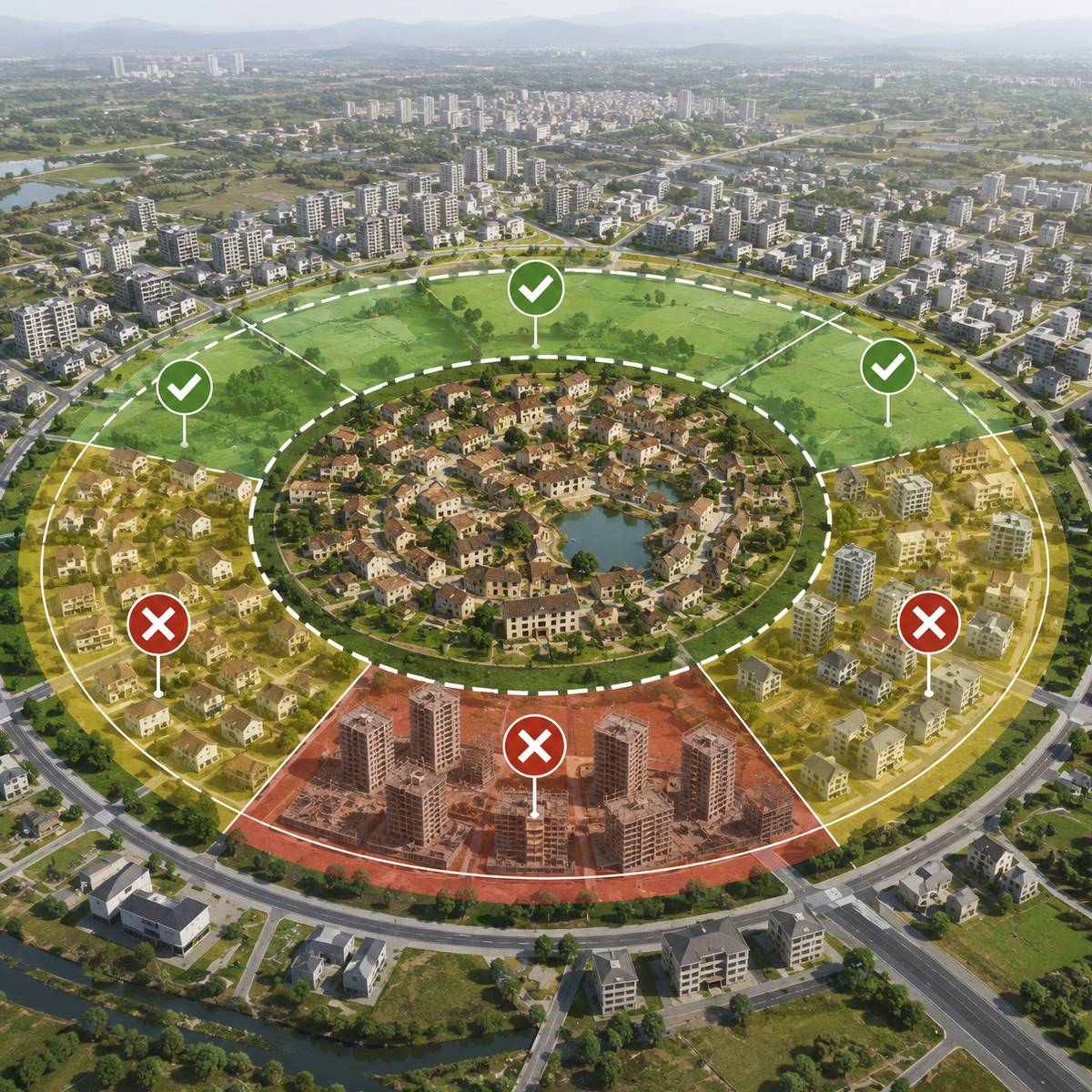
To prevent uncontrolled urban sprawl around traditional settlements, the DSIRDA development control regulations set distinct parameters for what can and cannot be built inside the buffer areas.DSIRDA Buffer Zone Development Rules
DSIRDA Buffer Zone Development Rules
Allowed
- Single-family homes (independent detached house, row house)
- Local retail shops and essential commercial stores
- Community buildings (schools, clinics, centers)
- Open greens, play access areas, and local village roads
Restricted / Prohibited
- Heavy industrial uses or toxic chemical plants
- Multi-story high-rise group housing projects
- Large-scale commercial malls without competent authority approval
Under these comprehensive development control rules, any new construction or renovation within the immediate surroundings of a village requires explicit clearance from the designated competent authority. These restrictions ensure that any new building respects the village fabric while offering access to clean water, potable water grids, proper sewage management, and upgraded water supply infrastructure.
Village Categorization in Ahmedabad District
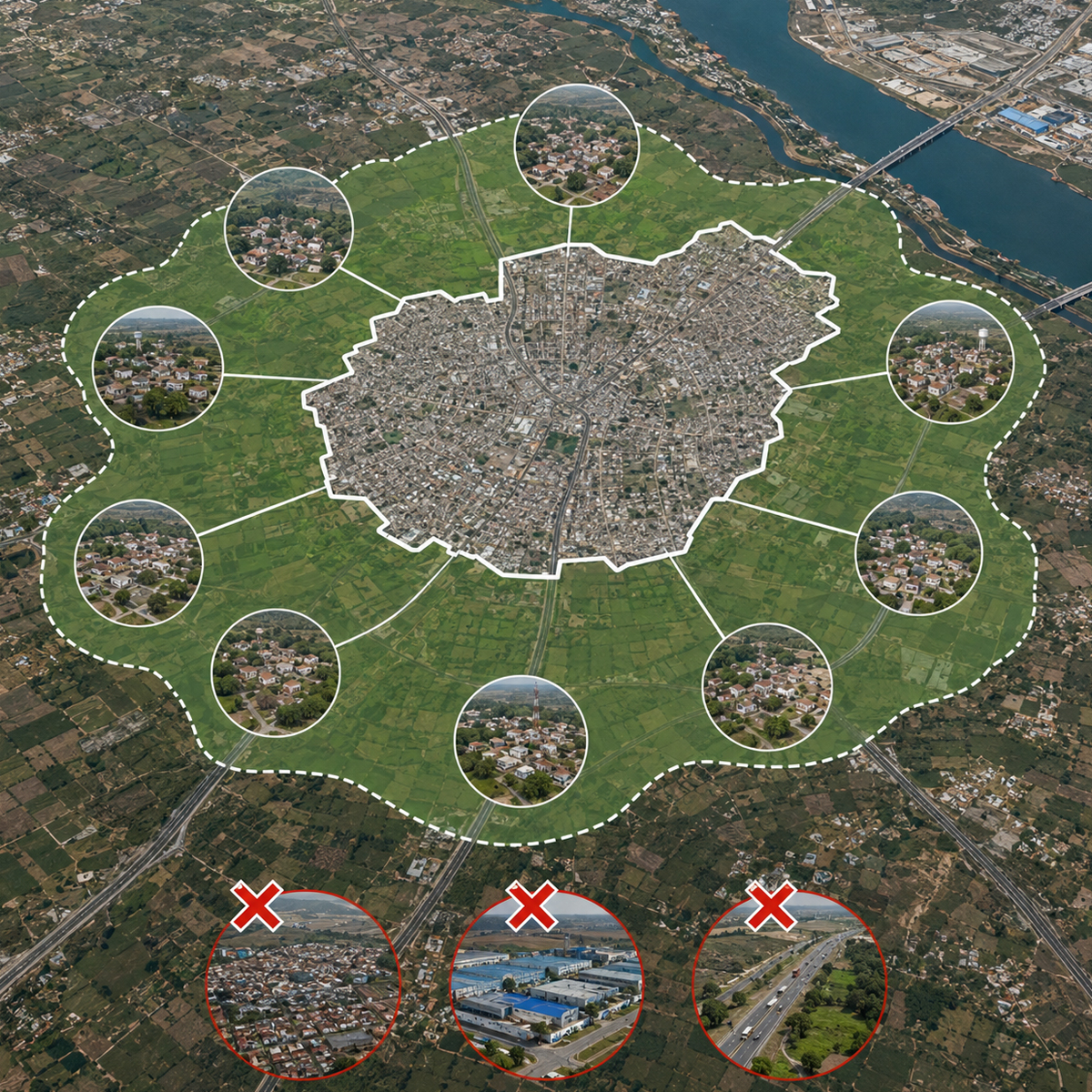
The buffer framework covers specific gamtal (village boundary) areas across the region in Ahmedabad district. Below is an overview of how local villages fall inside or outside this planning perimeter.
Villages Included in the Buffer Zone Perimeter
Villages located in close proximity to the main town planning scheme boundaries and major high access corridor zones feature buffer zones to protect their immediate environs. Commonly included village areas consist of:
Kadipur
Bhadiyad
Navagam
Mahadevpura
Zankhi
Otariya
Sodhi
Official List of Villages Excluded from the Buffer Zone
Certain villages sit entirely outside the primary activation area perimeter or fall under direct town planning (TP) schemes without needing a separate transitional buffer. These include:
Dholera Gamtal (core settlement subject to specific urban center rules)
Bavaliyari (classified under distinct coastal/industrial zones)
Pipli (aligned directly with regional transport corridors)
(Note: Always check the latest land use maps issued by DSIRDA to verify exact survey numbers before finalizing property transactions.)

Infrastructure Integration
While the buffer zone limits excessive construction, it does not leave village areas behind in terms of progress. The local layout works hand-in-hand with modern urban infrastructure projects taking shape nearby.
Utility Upgrades: Villages gain access to smart municipal networks, including underground gas trunklines, uninterrupted electrical connections, and modern potable water grids.
Connectivity: Upgraded village roads connect smoothly with arterial smart highways and dedicated access routes, allowing fast transit to the solar park and industrial hubs.
Environmental Safeguards: Dedicated green buffers safeguard rural settlements from air and noise pollution generated by surrounding industrial uses.
Digital & Service Support: Local technology and service centers (such as regional IT setups like impex infotech) support village digitized land records, helping locals maintain clarity and a strong sense of control over their legal property rights.

Property Investment Potential
Investing in land near the surrounding urban land of Dholera’s buffer areas comes with unique advantages and specific considerations for private investors.
Why Investors Consider Buffer Land
Low Entry Barriers: Land prices within or adjacent to buffer pockets are generally more accessible than core high-density commercial land.
Long-Term Growth: As urban environments expand, buffer properties benefit from nearby modern amenities while maintaining a peaceful environment.
Community Benefits: Property designated for residential premises, local retail, or community facilities sees steady demand from village populations and incoming workers.
Safety Checklist for Land Buyers
Verify Land Use Classification: Ensure the survey number allows your intended use under current development control regulations.
Confirm Approval Status: Obtain final approvals from DSIRDA before initiating construction or commercial projects.
Check Boundary Maps: Review official maps to ensure your parcel does not overlap with planned public utility corridors or restricted green belts.