
As the world rapidly modernizes, the need for intelligent, future-ready infrastructure has never been greater. At the forefront of this transformation is the Dholera SIR (Special Investment Region). As of 2026, the meticulous Dholera urban planning framework has transitioned from a visionary blueprint into a rapidly expanding reality. Supported by the Government of India, this ambitious project is redefining modern metropolitan living and cementing the nation’s place in the global manufacturing supply chain.
Core Philosophy Behind Dholera urban planning
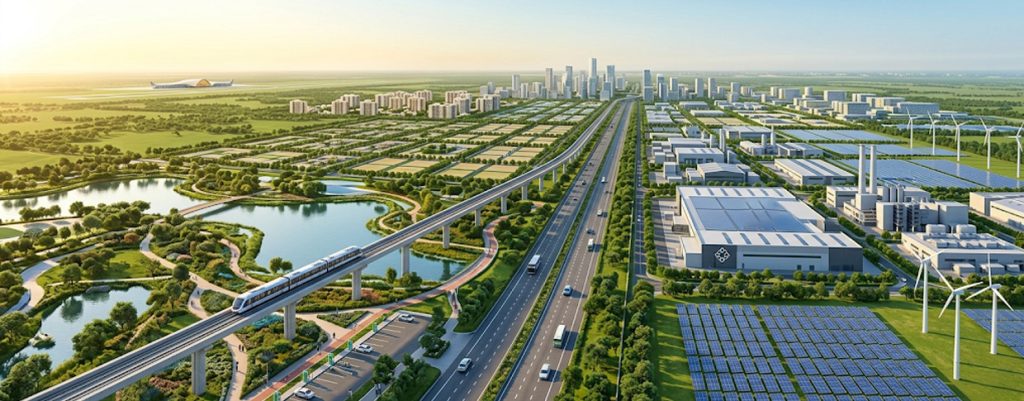
Dholera urban planning’s foundation rests on the concept of establishing a self-sustaining, highly efficient environment. Unlike older municipalities that must retrofit modern technology into outdated streets, this metropolis is being built from the ground up as India’s first greenfield smart city.
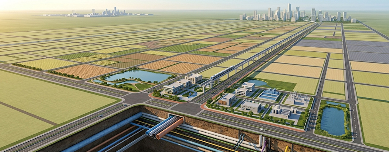
This “blank canvas” approach allows designers to implement state-of-the-art networks right from day one. The overarching city master plan spans a massive total area of 920 square kilometers. A major focus here is ensuring that rapid economic growth does not harm the ecosystem, strictly enforcing comprehensive development control regulations to balance industry and nature.
Incorporating Sustainable City Design and Green Energy
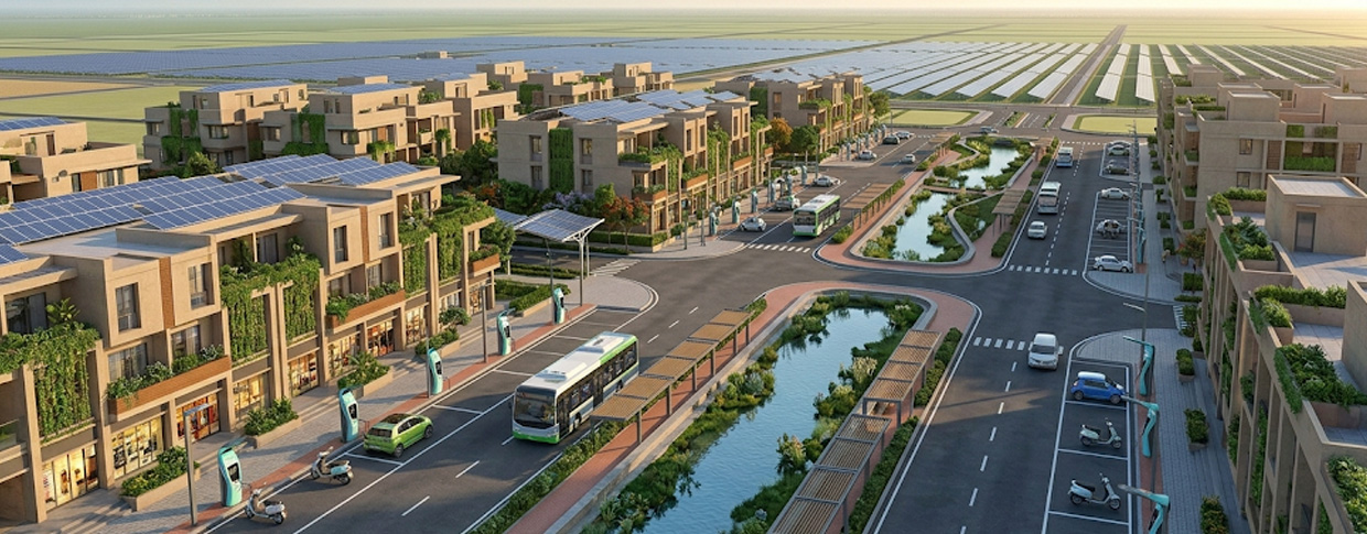
A hallmark of modern Dholera urban planning is an unwavering commitment to sustainable city design. Planners understand that a metropolitan area’s longevity depends entirely on its environmental impact.
Here are ways sustainable living is actively woven into the fabric of the region in 2026:
-
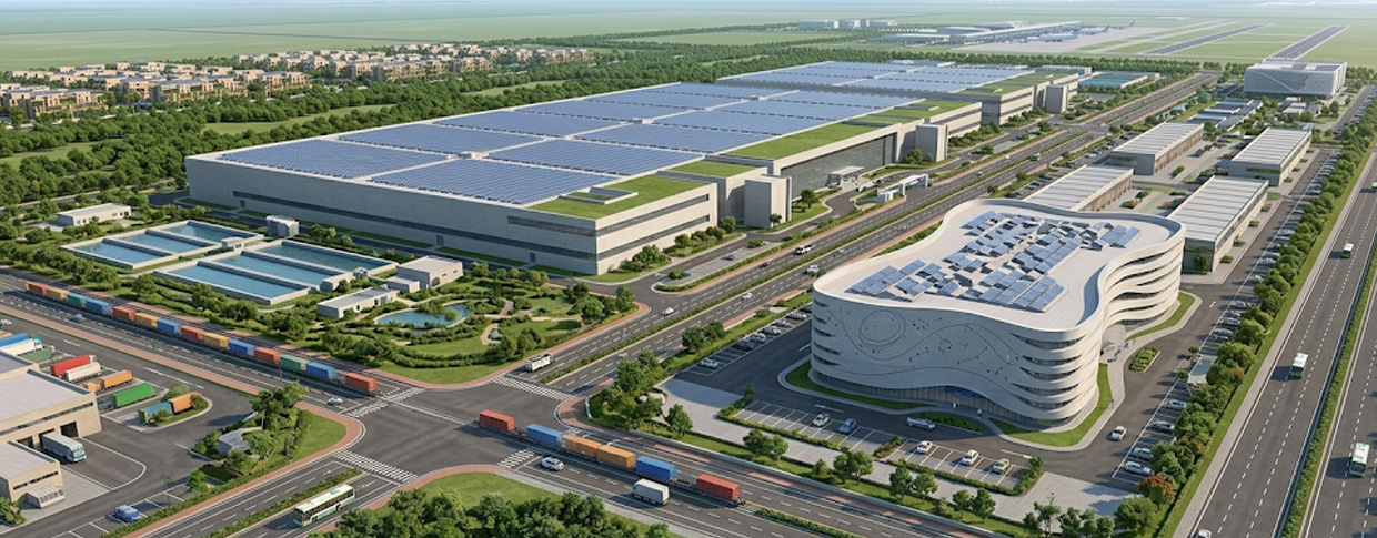
Renewable Energy Integration: The massive solar park is now actively generating solar power, providing clean, green energy to the growing commercial sectors.
-
Ecological Balance: The blueprint protects existing water bodies while creating new green corridors to maintain local biodiversity.
-
Smart Resource Conservation: Advanced rainwater harvesting, zero-waste discharge systems, and a highly monitored water supply ensure strict resource conservation.
2026 Milestones: Advanced Public Infrastructure
To support its booming economic sectors, this initiative utilizes an intricate “trunk infrastructure” model. This means all essential utilities are routed through underground ducts. This proactive public infrastructure minimizes the need for disruptive road excavations and significantly lowers long-term municipal operational costs.
Digital Connectivity and Smart Infrastructure
A key pillar of Dholera smart city is its technological backbone. Unprecedented digital connectivity allows for real-time monitoring of utilities, traffic, and emergency responses. This level of smart infrastructure ensures that public services are delivered efficiently and transparently to all residents and businesses.
The Semiconductor Boom and Industrial Clusters
Effective municipal design requires highly specific zoning. In 2026, the strategy regarding industrial zones is paying off massively. The region is emerging as a premier semiconductor powerhouse, anchored by a ₹91,000 crore fabrication plant.
This industrial development is organized into distinct industrial clusters to maximize efficiency. To support this explosive growth without causing sprawl, the local government is seamlessly integrating housing, ensuring residential areas remain close to commercial hubs.
How does Dholera’s urban planning differ from other smart cities in India?
This is a common question for investors. The primary difference lies in its foundation. While many projects focus on upgrading existing metropolitan areas, this is India’s first greenfield initiative of this scale. This means it is built on completely vacant land.
Furthermore, Dholera urban planning incorporates distinct, pre-planned economic zones meant to house heavy industry right alongside residential sectors, avoiding the chaotic urban expansion seen in older hubs. The sheer scale of the dholera smart city project makes it structurally unique compared to smaller retrofitted towns.
What agencies are responsible for Dholera’s urban planning and management?
The execution of this massive endeavor is a collaborative effort. The primary agency overseeing the ground-level execution is Dholera Industrial City Development Limited (DICDL), a special purpose vehicle.
This body represents a joint venture between the State of Gujarat (via the Government of Gujarat) and the central Indian government, operating under the guidance of the National Industrial Corridor Development Corporation (NICDC). Together, they ensure the smart city development aligns with national economic goals.
Where can I find the official documents related to Dholera’s development plan?
Investors and residents seeking transparency can access official documents, including the master plan and zoning maps, directly through the official DICDL website. These portals outline the key features of the project, environmental clearances, and detailed land allocation reports for the Dholera industrial city.
Understanding Land Use and the Activation Zone
The sheer size of the region meant that development had to be phased. The initial phase of land use is concentrated in the Activation Zone, a 22.5 square kilometer area designed to be the operational catalyst for the rest of the region. This zone already features functional utilities, roads, and administrative buildings.
Residential Plots and Daily Life
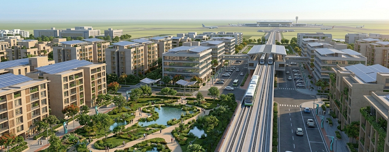
For those looking to move to the region, the availability of residential plots within well-designed neighborhoods promises a high quality of life. Daily life here is envisioned to be seamless, with schools, healthcare, and recreational parks located within walking distance or a short commute from residential nodes.
All Connectivity
Robust transit is the lifeblood of any major economic hub. The near-completion of the regional expressway has slashed travel times to nearby Ahmedabad. Furthermore, the upcoming Dholera International Airport is nearing operational readiness, providing critical global access for executives and cargo.
Integrating the Mass Rapid Transit System
To reduce carbon emissions locally, the layout prioritizes an electric mass rapid transit system. This integrated rapid transit system will seamlessly connect the airport, the industrial hubs, and residential blocks, minimizing reliance on private vehicles.
Close to Pipavav Port and Dedicated Freight Corridor
For logistical supremacy, the region leverages its strategic location. It is connected to the massive Western Dedicated Freight Corridor, facilitating the swift movement of goods. Additionally, its relative proximity to the bustling Pipavav Port provides maritime export capabilities, completing a world-class logistical triangle.
Conclusion: Dholera urban planning
As major anchor projects go live, the vision of a high-tech metropolis is a living reality. The meticulous approach to Dholera urban planning proves that with the right foresight, we can build environments that are economically robust and ecologically sound. By prioritizing advanced connectivity, clear zoning, and sustainable practices, this region is actively inventing the future of modern industrial living.